• 2 min read
AI pulls hidden ocean currents from satellite heat maps
Tel Aviv University researchers say GOFLOW can reconstruct ocean currents below 30 km from infrared satellite images, filling a key gap in climate data.
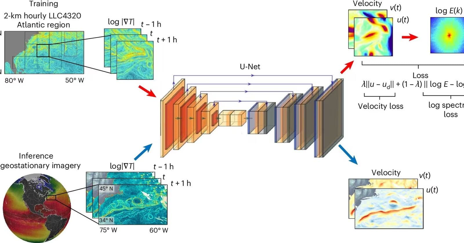
Image: ITzine
Scientists at Tel Aviv University have trained an AI system to recover small-scale ocean currents from satellite infrared images, exposing water motion at scales below 30 km that have largely been missed in routine observations.
That matters because the ocean covers more than 70% of Earth’s surface and acts as the planet’s giant heat exchanger. While major currents such as the Gulf Stream have long been tracked, many of the processes most important to climate science happen at smaller scales, where sharp temperature contrasts, flow convergence, and vertical water motion shape how heat, gases, and pollutants move through the ocean.
The system, called GOFLOW, was trained on modern computer models of the ocean and then tested on sequences of satellite images showing sea surface temperature. Unlike older approaches that relied on simplified physical assumptions, the researchers say GOFLOW infers hidden dynamics directly from the imagery and does a better job distinguishing complex flow structures.
Recommended reading
Soyuz-2 Reaches Vostochny for Russia’s Next Launch
The results were published in Nature Geoscience with DOI 10.1038/s41561-026-01943-0. According to the report, the practical gain is that scientists can now observe patterns that previously had to be reconstructed only from models or direct in-water measurements.
The researchers specifically highlight Gulf Stream dynamics at scales below 30 km and direct satellite-based estimates of horizontal divergence in ocean flows — zones where water spreads apart or converges, linked to vertical mass movement.
Why smaller-scale ocean flow matters
These features may be hard to spot on global maps, but they often control local ocean physics. Stronger mixing can change surface temperatures and, in turn, affect conditions for storms, cyclones, and extreme marine heat events. Better observations at this level could improve climate models, especially in regions where ocean-atmosphere exchange is critical.
There is also a more applied use case. Ocean currents move not just heat, but also plastic, chemical pollutants, nutrients, and dissolved gases. If GOFLOW can better identify convergence and divergence zones, it could help show where pollution will linger, where it may sink, and where it will spread.
Satellites already track sea surface temperature, sea level, and large eddies, but many models still struggle with the middle ground between the global picture and point measurements from buoys or expeditions. GOFLOW is aimed squarely at that gap — turning hidden small-scale ocean dynamics into a regular satellite-derived measurement.

Frontier Editor
Dan is our resident futurist, covering electric mobility, space exploration, and the smart home. He's interested in atoms just as much as bits. Whether it's a new battery chemistry, a reusable rocket, or a protocol that finally makes IoT devices talk to each other, Dan breaks down the engineering that pushes humanity forward.
via ITzine