• 4 min read
FireSat launches as wildfire smoke blankets North America
Three operational FireSat satellites are now in orbit, aiming to spot small wildfires through smoke and clouds before they spread.
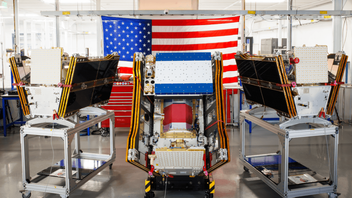
Image: Muon Space and Earth Fire Alliance
As smoke from hundreds of wildfires spread across Canada and the United States, the first three operational satellites in the Google-backed FireSat program launched successfully into orbit. The microsatellites rode a SpaceX Falcon 9 from Vandenberg Space Force Base in California on July 7, 2026, moving the nonprofit Earth Fire Alliance program into what it calls initial operational capability.
After a three-month testing period, the satellites are expected to begin supplying data to fire agencies while covering every fire-prone region on Earth at least twice per day. The group says FireSat is the first satellite constellation built specifically to detect wildfires, including smaller fires that other systems can miss.
The satellites were designed by California-based Muon Space. Google has provided more than $15 million for the initial deployment, while the Bezos Earth Fund committed $26 million. Each spacecraft carries multispectral imaging designed to see through smoke and clouds and detect fires as small as five by five meters—about 16 by 16 feet. That capability was first demonstrated by the FireSat Protoflight satellite, launched in March 2025, which collected more than one million images and detected low-intensity blazes invisible to existing satellites.
FireSat rollout and wildfire detection plans
The early users of FireSat data this year will include fire agencies in California, Colorado, Australia, and Portugal. As more satellites are added, the program aims to deliver imagery for any location in the world on an hourly basis by 2029, and every 20 minutes once the full constellation of more than 50 satellites is deployed by the early 2030s.
According to the Earth Fire Alliance, even an hourly revisit rate could help save more than $1 billion in fire damage, prevent nearly 22 million tons of carbon emissions, and protect 3,500 homes and 1.3 million acres of land. Google Research plans to use the company’s AI models to compare FireSat’s live data with historical images to identify very small fires and improve wildfire prediction. Google described the launch as “another tangible step forward in putting practical AI to work for climate resilience.”
Recommended reading
Starship V3 abort hits SpaceX stock and Starlink plans
Wildfire pressure grows as climate risks worsen
The article also notes the tension in Google’s role. While the company is backing wildfire detection, the broader expansion of AI infrastructure is driving up energy demand. Larger AI data centers in the United States are often being supported by new natural gas projects that could collectively emit more than 129 million tons of greenhouse gases per year, while Google’s company-wide electricity use grew by 37 percent in 2025.
FireSat may improve early detection, but it does not solve the resource problem on the ground. Fire agencies still need crews, prescribed burns, and aircraft to keep blazes from growing out of control. That challenge is becoming harder as global warming intensifies fires, especially in Canada’s boreal forests, where thousands of people in First Nations communities have had to flee fast-moving blazes this summer and smoke has exposed more than 100 million people to hazardous air pollution.
FireSat’s infrared imagery shows the Nipigon 6 fire in Ontario, Canada, on June 15, 2025, marking active fire regions at the top, active flames and burn scars in the middle, and older burn scars at the bottom.
“What is unfolding is what climate and forest scientists have been predicting for 30 years.” “That as the world gets hotter and drier, we are exposing forests to more and more risk, and the old strategies of fire suppression are simply being overwhelmed.”
The Canadian Wildland Fire Information System showed nearly 900 active wildfires in Canada as of July 17, with more than 3,600 wildfires so far this year burning more than 6.6 million acres. The federal government has leased 10 new aerial firefighting aircraft as surge assets for provinces, but dozens of fires remain out of control and are being monitored rather than actively suppressed.

Frontier Editor
Dan is our resident futurist, covering electric mobility, space exploration, and the smart home. He's interested in atoms just as much as bits. Whether it's a new battery chemistry, a reusable rocket, or a protocol that finally makes IoT devices talk to each other, Dan breaks down the engineering that pushes humanity forward.
via Ars Technica